+7
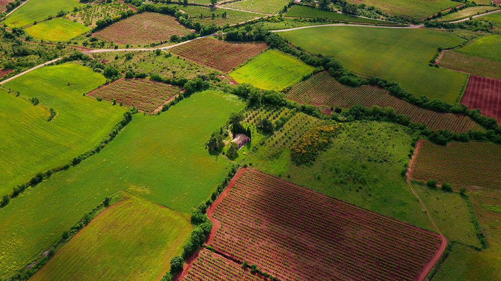
210 Acres for Sale in Buffalo Mountain (Owner Financing $1,695.00 a month), Nevada
$149,995
Property Details
Property Description
Rare Spectacular 210 Acres in Imlay NV-Summit Spring/Buffalo Mountain * Surrounded by BLM* Road Access * Water -Summit Spring * $149,995.00 Sale Price * $999,00 Deposit * $1,695.00 a month* APN: 009-370-02
$999.00 Down Payment To purchase go to www.commonlots.n
Property Description
Here are two adjoining parcels in Pershing County Nevada (210 Acre + 50 Acre Parcel) adjoining BLM Land Located South of Grass Valley and Buffalo Mountain Valley where the Summit Spring is Located! You won’t find a better location with road access and water at the properties along with the privacy of BLM Land around the properties. Great views! Looking down from Buffalo Mountain (elevation 8,211 ft) in central Nevada (located just off I-80 near Lovelock/Battle Mountain), you are taking in a quintessential Great Basin vista. You will see sweeping, fault-block terrains and the contrasting valleys below, including the striking Buffalo Valley and Valley of the Moon. Gold Mining in Buffalo Mountain, Nevada Buffalo Mountain is part of the Buffalo Valley–Bullfrog District in Nevada’s Humboldt and Pershing counties, a long-established gold-producing area with both historical placer mining and modern hard-rock exploration Western Mining History. Location and Geology Buffalo Mountain lies at the north end of the Tobin Range, north of Smelser Pass, extending toward Lone Tree Hill near I‑80, and south into Pershing County Western Mining History. The district is part of the Battle Mountain–Eureka Mineral Belt, known for Carlin-type gold deposits, gold skarn, and gold in pediment gravels lincolnmining.com. Gold mineralization here is controlled by north‑trending structural faults and favorable stratigraphy, often associated with intrusive bodies lincolnmining.com. Historical Mining Historically, the area has seen placer gold recovery from gravels, especially in the nearby Bullfrog Hills and Amargosa Valley near Beatty Western Mining History. These placer deposits are remnants of ancient gold-bearing streams and alluvial fans. Modern Mining Activity Today, Buffalo Mountain is linked to the Lone Tree and Buffalo Mountain gold deposits, which were acquired in 2021 by i‑80 Gold Corp. from Nevada Gold Mines www.i80gold.com. The Lone Tree property is a hard-rock gold mine with infrastructure to process refractory ores, giving i‑80 a strategic advantage in Nevada’s gold sector www.i80gold.com. The Buffalo Mountain site is part of this asset package, though specific production details are not widely publicized. Exploration Potential Geophysical surveys in the Buffalo Valley area have identified a swarm of north‑trending structures aligned with active mines to the north‑northeast, suggesting strong potential for new discoveries in the range of 3–5 million ounces of gold lincolnmining.com. Past work by Homestake identified three targets along the axial fault of the valley that were never drilled lincolnmining.com. Nearby Mines The district is close to other major producers such as Newmont at Lone Tree and Glamis/Barrick at Marigold, which have reported large gold-silver skarn discoveries lincolnmining.com. In summary: Buffalo Mountain is a historically placer-mined area with significant modern hard-rock development via the Lone Tree/Buffalo Mountain assets. Its geology, structural controls, and proximity to other high-grade deposits make it a key part of Nevada’s gold mining landscape.

Property Pricing, Terms & Doc/Recording Information and Pricing
$149,995.00 For Sale 210 Acres
$999.00 Deposit
$1,695.00 a month at 3.99% Interest-Low Interest
No Prepayment Penalty
No Credit Check
Property Legal information
Size: 160 Acres
APN 009-370-02 in Pershing County, NV
Legal description: T32 R41 Sec 18
Size: 50 Acres
APN 009-370-03 in Pershing County, NV
Legal description: Section 16 SW 1/4 SW 1/4
GPS coordinates
Center
40.64195, -117.3743 Northwest
40.6437, -117.3767 Northeast
40.6437, -117.3719Southwest
40.6392, -117.3767Southeast
40.6392, -117.3719
About the Area
Looking down from Buffalo Mountain (elevation 8,211 ft) in central Nevada (located just off I-80 near Lovelock/Battle Mountain), you are taking in a quintessential Great Basin vista. You will see sweeping, fault-block terrains and the contrasting valleys below, including the striking Buffalo Valley and Valley of the Moon. The topography of this area is heavily shaped by tectonic stretching and volcanic history. Looking directly off the slopes, your view features: Buffalo Valley: The massive basin spreading directly below the mountain. Historical relics: Look for traces of old mining and survey landmarks (this area was notably surveyed by Howard Hughes).Basin and Range extension: A dramatic look at how the Earth’s crust has been slowly pulled apart, dropping the valleys far below the surrounding ridgelines. Surrounding summits: Panoramic views toward Mt. Tobin and the expansive central Nevada outback.
Gold Mining in Buffalo Mountain, Nevada
Buffalo Mountain is part of the Buffalo Valley–Bullfrog District in Nevada’s Humboldt and Pershing counties, a long-established gold-producing area with both historical placer mining and modern hard-rock exploration Western Mining History.
Location and Geology
Buffalo Mountain lies at the north end of the Tobin Range, north of Smelser Pass, extending toward Lone Tree Hill near I‑80, and south into Pershing County Western Mining History. The district is part of the Battle Mountain–Eureka Mineral Belt, known for Carlin-type gold deposits, gold skarn, and gold in pediment gravels lincolnmining.com. Gold mineralization here is controlled by north‑trending structural faults and favorable stratigraphy, often associated with intrusive bodies lincolnmining.com.
Historical Mining
Historically, the area has seen placer gold recovery from gravels, especially in the nearby Bullfrog Hills and Amargosa Valley near Beatty Western Mining History. These placer deposits are remnants of ancient gold-bearing streams and alluvial fans.
Modern Mining Activity
Today, Buffalo Mountain is linked to the Lone Tree and Buffalo Mountain gold deposits, which were acquired in 2021 by i‑80 Gold Corp. from Nevada Gold Mines www.i80gold.com. The Lone Tree property is a hard-rock gold mine with infrastructure to process refractory ores, giving i‑80 a strategic advantage in Nevada’s gold sector www.i80gold.com. The Buffalo Mountain site is part of this asset package, though specific production details are not widely publicized.
Exploration Potential
Geophysical surveys in the Buffalo Valley area have identified a swarm of north‑trending structures aligned with active mines to the north‑northeast, suggesting strong potential for new discoveries in the range of 3–5 million ounces of gold lincolnmining.com. Past work by Homestake identified three targets along the axial fault of the valley that were never drilled lincolnmining.com.
Nearby Mines
The district is close to other major producers such as Newmont at Lone Tree and Glamis/Barrick at Marigold, which have reported large gold-silver skarn discoveries lincolnmining.com.
In summary: Buffalo Mountain is a historically placer-mined area with significant modern hard-rock development via the Lone Tree/Buffalo Mountain assets. Its geology, structural controls, and proximity to other high-grade deposits make it a key part of Nevada’s gold mining landscape
Disclaimer From LandCentury
The information within this listing is posted by a private or third-party seller, and we do not guarantee the accuracy of the information enclosed. We encourage you always to verify ownership and property details listed. As a precaution, due diligence in any real estate transaction is encouraged, and closing through a verified title company is advised. To the maximum extent permitted by law, we do not accept any responsibility to any person for the accuracy of the information herein.